Read the projects related to environmental parameters mapping more analytically in chronological order:
Eurostat - European Commission LUCAS (2009)
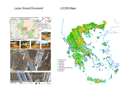
2009 : Land Use/Cover Area frame statistical Survey (LUCAS) 2009 – Agro-Environmental Survey: Field work in Greece, Italy and Slovenia.
Project Description
LUCAS 2009 is a survey on the state and the dynamics of changes in land use and cover in the European Union. The LUCAS 2009 survey covers all 27 EU countries.
Eurostat - European Commission LUCAS (2012)
2012 : Land Use/Cover Area frame statistical Survey (LUCAS) 2012 – Agro-Environmental Survey: Field work in Greece, Italy and Slovenia
Project Description
LUCAS 2012 is a survey on the state and the dynamics of changes in land use and cover in the European Union. The LUCAS 2012 survey covers all 27 EU countries.
Eurostat - European Commission LUCAS (2015)
2015 : Land Use/Cover Area frame statistical Survey (LUCAS) 2015 – Agro-Environmental Survey: Field work in Greece, Italy and Slovenia.
Project Description
LUCAS 2015 is a survey on the state and the dynamics of changes in land use and cover in the European Union. The LUCAS 2015 survey covers all 27 EU countries.